
ALPS 2 OCEAN CYCLE TRAIL
NZ’s Epic Ride
The Alps 2 Ocean Cycle Trail in New Zealand is truely one of NZ’s great rides – from our highest mountains, past great lakes and rivers, and down to the ocean.
The full tour is over 300 km and dropping in altitude 780m, visitors can experience some of the most beautiful scenery New Zealand has to offer as the mix of on and off-road trails link the Southern Alps to the mighty Pacific Ocean.

ONE OF NZ’S TRUELY GREAT RIDES
The Alps 2 Ocean Cycle Trail is NZ in all its colour and natural beauty
The Alps 2 Ocean Cycle Trail is NZ in all its colour and natural beauty
The Cycle Trail starts at the base of the majestic Aoraki Mt Cook in the National Park or alternatively at Tekapo, with both routes meeting on the shores of the turquoise waters of Lake Pukaki.
From there the Trail takes in Twizel and the shoreline of Lake Ohau before climbing to the highest point on the Trail where you view the magnificence of the Mackenzie Basin before dropping down to Omarama.
The Waitaki Valley delivers a geo-park of wonders, you meander past more lakes and rivers, ride through vineyards and experience ever changing vistas on your way towards the Pacific coast. Your final destination is Oamaru, a town famous for its neo classical ‘Oamaru Stone’ Victorian buildings, art galleries and the little blue penguins.


Trail Details & Maps
Distance: 35km Fitness: Easy Skill: Moderate Traffic: Low Grade: 2
The Alps 2 Ocean Cycle Trail starts at the White Horse Hill Campground, which is 2km north of Mt Cook Village. From here, a 7.2km off-road trail takes you to Mount Cook Airport [8km], where riders will need to make a short helicopter flight across the Tasman River to Tasman Point. Travelling in a helicopter across a glacially-fed braided river with New Zealand’s highest mountain in view is a must do. The helicopter can carry up to 6 passengers at a time (depending on weight limits).
From Tasman Point it’s 10.6km to the Jollie Car Park at the top of Hayman Rd [18km]. This track is rough in places and includes several creek crossings. On a clear day this section of trail offers views of Aoraki/Mt Cook, which at 3,754 metres towers above a range of snow washed peaks in the Aoraki/ Mt Cook National Park. From the car park, it’s 16.8km on gravel road to Braemar Road.
Distance: 54km Fitness: Easy Skill: Easy Traffic: Low Grade: 2
The Alternative Route begins just outside Tekapo township in the Lakeside car park which is accessed via Hamilton Drive off SH8. Following the red Trail markers will take you on the off-road track beside the main road in to the Lake Tekapo Village. You are permitted to use the pedestrian path across the road bridge, but please give way to pedestrians, they have priority.
Follow this track until you reach Aorangi Crescent [2.2km], turn left here and continue along Aorangi Crescent then turn right into Andrew Don Drive [0.5km]. There is a new subdivision being built here so be aware of construction traffic. Eventually Andrew Don Drive becomes a gravel road [0.8km].
Passing Tekapo A Power Station [3km] continue along the Tekapo Canal Road to the gate where vehicles are excluded [9km].
Take care crossing SH8 [15km] then continue on past the Mt Cook Alpine Salmon farm and the toilet [24km], before dropping down to Lake Pukaki [30km]. Turn left onto Hayman Road and ride to the start of the off-road trail on your right [35km], which follows the Lake Pukaki shoreline.
With Aoraki/Mt Cook as a backdrop, the Trail passes over the Pukaki dam, taking you to the car park and toilets. The Mt Cook Alpine Salmon shop [44km] also has Cycle Trail maps on the wall and general tourist information.
You then cross the highway and follow the Trail across Pukaki Flats – an expansive area of dry grasslands that are characteristic of the Mackenzie landscape. This takes you to the town of Twizel [54km].
Take care crossing the State Highway.
The trail continues along a quiet country road that follows the eastern shore of Lake Pukaki, passing the Tekapo B power station [18km]. Riders will enjoy outstanding vistas across Lake Pukaki towards the Southern Alps. A wide range of native plants grow along the lake edge including kowhai and flax, as well as exotic species such as larch and pines.
The off-road trail starts at the bottom of Hayman Road [23km] and follows the Lake Pukaki shoreline. With Aoraki/ Mt Cook as a backdrop, the trail passes over the Pukaki dam, taking you to the car park at Lake Pukaki Visitor Centre [31km]. You then cross the highway and follow the trail across Pukaki Flats – an expansive area of dry grasslands that are characteristic of the Mackenzie landscape. This takes you to the town of Twizel. Take care crossing the State Highway.

Distance: 38km Fitness: Easy Skill: Easy Traffic: Low Grade: 2
From Twizel, you follow Mackenzie Drive, then Nuns Veil Road which takes you to Glen Lyon Road. Follow this until it crosses the canal bridge just past Loch Cameron [6km]. After crossing the bridge, stay on the two lane northern side of the canal road until reaching the edge of Lake Ohau [18km]. From there an off-road trail descends down to the lake foreshore, taking you to the Ohau Weir [20km].
After the weir the trail skirts around the lake foreshore where it eventually meets up with the sealed Lake Ohau Road [29km]. Follow the road for the final 10km to Lake Ohau Lodge (you go past Lake Ohau Village).

Distance: 45km Fitness: Intermediate Skill: Intermediate Traffic: Low Grade: 3
Starting from the Lake Ohau Lodge driveway, the trail traverses the lower slopes of the Ruataniwha Conservation Park, with stunning views back across the basin to the Ben Ohau Range. 6km of easy cycling will take you to Freehold Creek, 600m above sea level. From here the track narrows and it’s a steady climb to the high point on the trail at 900m [11km].
Please be aware that there are several ‘false summits’ where the trail appears to reach the high point, but instead keeps winding upward. There is plenty of clean drinking water available from the various streams that flow down from the mountains. Once at the high point it is a rolling descent to the historic woolshed at the top of Quailburn Road [19km]. Toilets and parking are available here.
On the way down Quailburn Road you can turn onto Henburn Rd [36km] and take a side trip to see the Clay Cliffs (14km return).
Where Quailburn Road meets the highway, take the off-road trail which leads through the Ahuriri Camp Ground [42km]. Exit the camp ground and cross over the Ahuriri river using the road bridge. A short off-road trail then takes you to Omarama.

Distance: 35km Fitness: Easy Skill: Easy Traffic: Moderate Grade: 3
Leaving Omarama you ride east down the Waitaki Valley, following the off-road Trail to the top of the Chain Hills 5km. From here, you descend beside State Highway 83, then follow the edge of Lake Benmore to Pumpkin Point [10km].
Continue beside the lake to Sailors Cutting – a popular boating, fishing and camping destination 13km. Following the A2O signs through the campground. Your next 16km includes a mix of Grade 2 and narrower Grade 3 Trail.
Arriving at Benmore Dam car park 29km, you have a choice to take the Cycle Trail in to Otematata [12km return] or continue over the Dam to Kurow (Section 6) – a further 38km away at this point.
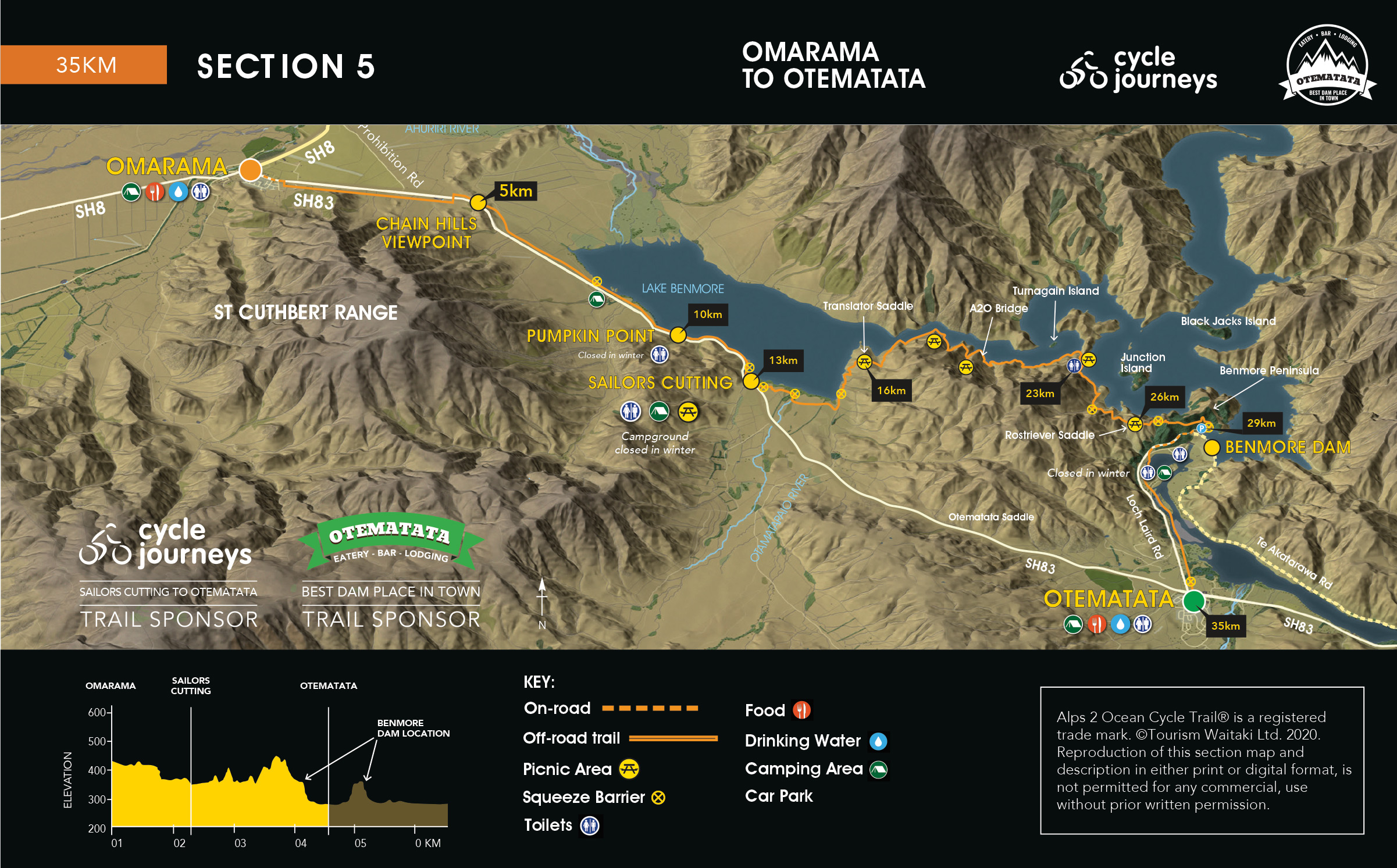
From Otematata, take the sealed payhway beside Loch Laird Road, then follow the gravel track beside the lake. This takes you through several camping areas. You then ride up Loch Laird Road onto the massive Benmore Hydro Dam [6km]. It’s a steep road up to the dam, so you may need to walk the last 800 metres.
Follow the Te Akatarawa Road along the margins of Lake Aviemore to the Aviemore Dam [28km]. After crossing the dam the trail follows State Highway 83 to Lake Waitaki and the Waitaki Dam [36km], then to Kurow. This section of trail has an interesting hydro history with dams and project towns.

Distance: 28km Fitness: Easy Skill: Easy Traffic: Low Grade: 2
The off-road trail starts at the eastern end of Kurow between the museum sheds. A gravel track takes you across to the Waitaki River which you follow down the valley. You cross Kurow Creek [3km] then ride up and alongside the highway.
You ride through the winery [5km], then ride back towards the Waitaki River and follow the Waitaki Haul Road, crossing the Otiake River [11km] and the Otekaieke River [15km]. This section of the old Haul Road is shared with recreational vehicles.
The trail then follows the highway to the Takiroa Maori rock art site [23km] which is across the road from the trail. After visiting the rock art site, retrace your steps and continue on the trail that heads back down to the Waitaki River and through to Harris St. Halfway up Harris St you turn right and ride through the Duntroon Wetlands before emerging in the centre of Duntroon.

Distance: 54km Fitness: Intermediate Skill: Easy Traffic: Medium Grade: 3
From Duntroon you head south-west to the unique rock formations known as Elephant Rocks [6km]. An off-road trail then takes you through several farms. You rejoin the road at Prydes Gulley which takes you to Island Cliff [13km] which is surrounded by limestone escarpments. Keep veering right on the road until you get to Karara Creek where you go off-road again.
A series of gravel roads (Cants, Peaks then Tunnel Rd) take you to the Rakis Railway Tunnel [27km] where there is a toilet, picnic spot and drinking water. Next stop is Windsor [33km], then an off-road section of trail takes you through farmland to Enfield [42km] and onto Weston [48km] where you rejoin the old railway line for a flat run to Saleyards Rd.
Follow the sealed cycleway downhill to the Oamaru Gardens. Bike through the gardens, across SH1, then through the park to the main street (Thames Street). Turn right into the far lane and ride south past the i-SITE, turning left on Itchen St, right onto Tyne, then left onto Harbour St. Go through the Victorian Historic Precinct to the Oamaru Harbour where the trail ends at Friendly Bay and the Pacific Ocean!

We are an Alps 2 Ocean Official Partner
Established in 2012, the Alps 2 Ocean Official Partner Programme recognises that the physical cycle trail is only one part of the overall product that will attract cyclists to the Mackenzie and Waitaki Districts. In addition to a high-quality trail, cyclists require services such as transport, accommodation, bike hire, food and activities for when they are not cycling. They expect a high level of customer service and appreciate a warm welcome.